Showing posts with label houses. Show all posts

Tuesday, 12 July 2022

DESKTOP 3264 - SANTORINI

Santorini (Greek: Σαντορίνη), classically Thera (Greek: Θήρα); is an island in the southern Aegean Sea, about 200 km southeast of Greece's mainland. It is the largest island of a small, circular archipelago which bears the same name and is the remnant of a volcanic caldera. It forms the southernmost member of the Cyclades group of islands, with an area of approximately 73 km2 and a 2011 census population of 15,550. The municipality of Santorini comprises the inhabited islands of Santorini and Therasia and the uninhabited islands of Nea Kameni, Palaia Kameni, Aspronisi, and Christiana. The total land area is 90.623 km2.
 
Santorini is part of the Thira regional unit. Santorini is essentially what remained after an enormous volcanic eruption that destroyed the earliest settlements on a formerly single island, and created the current geological caldera. A giant central, rectangular lagoon, which measures about 12 by 7 km, is surrounded by 300 m high, steep cliffs on three sides. The main island slopes downward to the Aegean Sea. On the fourth side, the lagoon is separated from the sea by another much smaller island called Therasia; the lagoon is connected to the sea in two places, in the northwest and southwest. The depth of the caldera, at 400m, makes it possible for all but the largest ships to anchor anywhere in the protected bay; there is also a newly built marina at Vlychada, on the southwestern coast. The island's principal port is Athinias.
 
The capital, Fira, clings to the top of the cliff looking down on the lagoon. The expansion of tourism has resulted in the growth of the economy and population. The major settlements include Fira (Phira), Oia, Emporio, Kamari, Perissa, Imerovigli, Pyrgos, and Therasia. Akrotiri is a major archaeological site, with ruins from the Minoan era. Santorini's primary industry is tourism, particularly in the summer months. Santorini was ranked world's top island for many other magazines and travel sites, including the Travel+Leisure Magazine, the BBC, as well as the US News.

This post is part of the Travel Tuesday meme,
and part of the Ruby Tuesday meme.

Tuesday, 17 May 2022

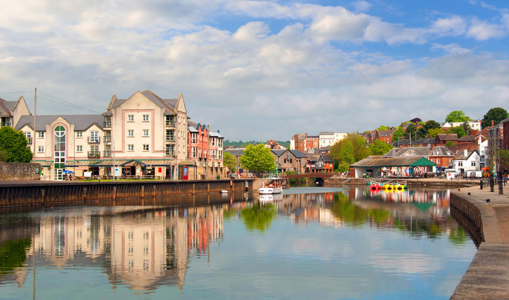
DESKTOP 3210 - EXETER, UK

Exeter is a cathedral city in Devon, England with a population of 129,800 (mid-2016 est.). It lies within the county of Devon, of which it is the county town as well as the home of Devon County Council. The administrative area has the status of a non-metropolitan district under the administration of the County Council; a plan to grant the city unitary authority status was scrapped under the 2010 coalition government. 

The city is on the River Exe about 60 km northeast of Plymouth and 110 km southwest of Bristol. Exeter was the most south-westerly Roman fortified settlement in Britain, although there is evidence a Cornish tribe existed in Exeter before the Roman invasion. Exeter became a religious centre during the Middle Ages and into the Tudor times: Exeter Cathedral, founded in the mid 11th century, became Anglican during the 16th-century English Reformation.

During the late 19th century, Exeter became an affluent centre for the wool trade, although by the First World War the city was in decline. After the Second World War, much of the city centre was rebuilt and is now considered to be a centre for modern business and tourism in Devon and Cornwall.

This post is part of the Travel Tuesday meme,
and also part of the Ruby Tuesday meme.


Tuesday, 10 May 2022

DESKTOP 3203 - BURANO, ITALY

Burano is an island in the Venetian Lagoon, northern Italy; like Venice itself, it could more correctly be called an archipelago of four islands linked by bridges. It is situated near Torcello at the northern end of the Lagoon, and is widely known for its fine lace work, which is very expensive because it is extremely time-consuming to make. 

Burano is also known for its small, brightly painted houses, which are popular with photographers and artists. The colours of the houses follow a specific system originating from the golden age of its development. If someone wishes to paint their home, one must send a request to the local government authority, which will respond by making notice of the certain colours permitted for that lot.

Other attractions include the Church of San Martino, with a leaning campanile and a painting by Giambattista Tiepolo (Crufixion, 1727), the Oratorio di Santa Barbara and the Museum and School of Lacemaking.

This post is part of the Travel Tuesday meme,
and also part of the Ruby Tuesday meme.


Tuesday, 20 April 2021

DESKTOP 2819 - POROS, GREECE

The island of Poros is situated off the East coast of the Peloponnesus, a stone’s throw away from the little coastal town of Galatas.  Less than an hour’s journey from Athens' port, Piraeus, on the Flying Dolphin hovercraft, it is a magical place to visit, exemplifying in many ways the picture of a Greek island most people have in their imagination. 
 
It is a small place, in reality two islands that are joined together by a short isthmus. The smaller of the two is Sphaeria, and the larger one Calavria. Ancient settlements on both islands are known from references in ancient authors, but little now remains in the form of ruins. A few slabs of marble from a temple of Poseidon on a wind-blown hill surrounded by pine trees, schinum bushes and yellow stubbly summer-dried grass is enough to evoke ancient mysteries while one gazes at the deepest azure of the sea stretching out to the horizon.

Swimming in the sea while the heat is at its most intense is easily accomplished at any of a hundred or more suitable places all around the coast. A little to the North of the Neorion bay about 100 meters from the main road joining the two islands is an enchanting little cove, “Love Bay”. The water is an aqueous greenish blue, crystal clear, reflecting the overhanging pine boughs from the trees that grow almost to the water’s edge.

This post is part of the Our World Tuesday meme,
and also part of the Ruby Tuesday meme,
and also part of the Travel Tuesday meme,
and also part of the Wordless Wednesday meme.


Tuesday, 5 January 2021

DESKTOP 2714 - HAMBURG, GERMANY

Hamburg, officially Freie und Hansestadt Hamburg (Free and Hanseatic City of Hamburg), is the second largest city in Germany and the eighth largest city in the European Union. It is the second smallest German state by area. Its population is over 1.7 million people, and the wider Hamburg Metropolitan Region covers more than 5.1 million inhabitants. The city is situated on the river Elbe. The official long name reflects its history as a member of the medieval Hanseatic League, as a free imperial city of the Holy Roman Empire, a city-state, and one of the 16 states of Germany.

Before the 1871 Unification of Germany, it was a fully sovereign state. Prior to the constitutional changes in 1919, the civic republic was ruled by a class of hereditary grand burghers or Hanseaten. Though repeatedly destroyed by great fires, floods and military conflicts including WW2 bombing raids, the city managed to recover and emerge wealthier after each catastrophe. Hamburg is a transport hub, being the 2nd largest port in Europe by TEU's and the 3rd largest by cargo, and is an affluent city in Europe.

It is a global service, media, logistics and industrial hub, with headquarters and facilities of Airbus, Blohm + Voss, Aurubis, Beiersdorf, Unilever and a range of innovative startups. The radio and television broadcaster NDR, Europe's largest printing and publishing firm Gruner + Jahr and the Spiegel company are pillars of the media industry in Hamburg. Hamburg is an important financial centre for centuries, and is the seat of Germany's oldest stock exchange and the world's second oldest bank, Berenberg Bank.

This post is part of the Our World Tuesday meme,
and also part of the Ruby Tuesday meme,
and also part of the Travel Tuesday meme,
and also part of the Wordless Wednesday meme.


Tuesday, 11 August 2020

DESKTOP 2567 - CORNWALL

Cornwall (Cornish: Kernow) is a ceremonial county and unitary authority area of England within the United Kingdom. It is bordered to the north and west by the Celtic Sea, to the south by the English Channel, and to the east by the county of Devon, over the River Tamar. Cornwall has a population of 536,000 and covers an area of 3,563 km2. The administrative centre, and only city in Cornwall, is Truro, although the town of Falmouth has the largest population for a civil parish and the conurbation of Camborne, Pool and Redruth has the highest total population. Cornwall is the homeland of the Cornish people and is recognised as one of the Celtic nations, retaining a distinct cultural identity that reflects its history.

Looe (Cornish: Logh, meaning deep water inlet) is a small coastal town, fishing port and civil parish in the former Caradon district of south-east Cornwall, UK, with a population of 5,280 at recent census (2001 & 2011 census). The two electoral wards mentioning Looe but also including Polperro had a total population of 7,117 at the 2011 census.The town of Looe is approximately 32 km west of the city of Plymouth and 11 km south of Liskeard. and is divided in two by the River Looe, East Looe and West Looe (Cornish: Porthbyhan, meaning Little Cove) being connected by a bridge. The town centres around a small harbour and along the steep-sided valley of the River Looe which flows between East and West Looe to the sea beside a sandy beach. Off shore to the west, opposite the stonier Hannafore Beach, lies the idyllic St George’s Island, otherwise known as Looe Island.

Looe’s main business today is tourism, with much of the town given over to hotels, guest houses and holiday homes, along with a large number of pubs, restaurants and beach equipment, ice cream and Cornish pasty vendors. Inland from Looe lie many camping and caravan sites, as well as the famous Woolly Monkey Sanctuary. Other local attractions include the beaches, sailing, fishing and diving, and spectacular coastal walks (especially via Talland to Polperro).

This post is part of the Our World Tuesday meme,
and also part of the Ruby Tuesday meme,
and also part of the Travel Tuesday meme,
and also part of the Wordless Wednesday meme.

Tuesday, 28 April 2020

DESKTOP 2462 - SYMI, GREECE

Symi island belongs to the Dodecanese islands complex and lies 24 nautical miles NW of Rhodes and 255 nautical miles from the port of Piraeus. The highest point is Mountain Vigla at 616 metres. The island is very close to the coast of Asia Minor, just 5 miles from Alopos in Turkey. It is not a very big island, only 67 square kilometres. The majority of the land is covered in rocks. Two settlements form the town of Symi: Chorio (Village) and Yalos ( Harbour). Pedi, found in the bay of the same name and Nimporios in the bay of the same name, have a few inhabitants. There is also a big monastery complex, Panormitis, where around 30 people live and take care of the monastery.

This post is part of the Our World Tuesday meme,
and also part of the Blue Monday meme,
and also part of the Travel Tuesday meme,
and also part of the Wordless Wednesday meme.
 

Tuesday, 3 March 2020

DESKTOP 2406 - PARGA, GREECE

Parga (Greek: Πάργα [ˈpaɾɣa]) is a town and municipality located in the northwestern part of the regional unit of Preveza in Epirus, northwestern Greece. The seat of the municipality is the village Kanallaki. Parga lies on the Ionian coast between the cities of Preveza and Igoumenitsa. It is a resort town known for its scenic beauty. In antiquity the area was inhabited by the Greek tribe of the Thesprotians. The ancient town of Toryne was probably located here.

The village of Parga stands from the early 13th century. It was originally built on top of the mountain "Pezovolo". In 1360 the Pargians, in order to avoid the attacks of the Magrebins, transferred the village to its present location. During that period, with the help of the Normans, who held the island of Corfu, the fortress of Parga was built. In 1401 a treaty was signed with the Venetians, and the rule of Ionian Islands passed to them. The Venetians respected the lifestyle of the Pargians who provided, in turn, invaluable assistance to the fleet of the Venetians. At the same time the Pargians fought by the side of their compatriots to throw off the Ottoman rule. As Parga was the only free Christian village of Epirus, it was a perfect refuge for persecuted fighters and their families.

In 1797 the area, along with the Ionian Islands and Parga, fell into the hands of the French, and in 1800, proclaimed free city status with broad authority under the protection of the Sublime Porte. In 1815, with the fortunes of the French failing, the citizens of Parga revolted against French rule and sought the protection of the British. In 1817, following a treaty between Britain and the Ottoman Empire, the British granted Parga to the Ottomans. This resulted in the Good Friday of 1819 where 4,000 Pargians, having with them the ashes of the bones of their ancestors, their sacred images, flags and a handful of soil from their homeland, exiled themselves in the British protectorate of Corfu where they settled.

The former citizens of Parga never ceased to dream of returning to a free country and to participate actively in the struggle for liberation. But they had to wait almost 100 years for this. Parga and the rest of Epirus was liberated from the Ottoman rule on 1913 following the victory of Greece in the Balkan Wars.

This post is part of the Our World Tuesday meme,
and also part of the Ruby Tuesday meme,
and also part of the Travel Tuesday meme,
and also part of the Wordless Wednesday meme.

Tuesday, 4 February 2020

DESKTOP 2378 - KAYSERBERG, FRANCE

Kaysersberg is a commune in the Haut-Rhin department in Alsace in north-eastern France. The inhabitants are called Kaysersbergeois. The name means "Emperor's Mountain" in German. The high fortress that dominates the city serves as a reminder of both its strategic importance and its warlike past.

Kaysersberg is the birthplace of Albert Schweitzer (1875–1965), theologian, musician, philosopher, and physician. Together with the rest of Alsace-Lorraine, Kaysersberg was part of Germany during the period between the Franco-Prussian War and the First World War.

Kaysersberg is one of the finest wine growing areas in Alsace. The first vines were brought here in the 16th century from Hungary, and wine production is still an important aspect of the town’s economy today. Wine produced from the Pinot gris variety is a local specialty.

This post is part of the Our World Tuesday meme,
and also part of the Ruby Tuesday meme,
and also part of the Travel Tuesday meme,
and also part of the Wordless Wednesday meme.

Tuesday, 14 January 2020

DESKTOP 2357 - LEONIDIO, GREECE

Leonidio (Greek: Λεωνίδιο) is a town and a former municipality in Arcadia, Peloponnese, Greece. Since the 2011 local government reform it is part of the municipality South Kynouria, of which it is a municipal unit. It is considered a traditional settlement. The town of Leonidio, with a population of 3.826, emerges from a spectacular landscape, bound by two abrupt mountainsides enclosing the town from the north and south. The River Dafnon passes through the town, and it is crossed by three bridges. 

The town is capital of the Tsakonia region, notable for its cultural and linguistic particularities, and the settlement itself offers striking and picturesque architecture. It is now a protected architectural site and there are very strict regulations for building within the town limits. The convent of the Virgin of Elone is built on a craggy cliff near Leonidio and the first church there dates from the 1300s. The present convent is built on the ruins of the first church and dates from 1809. 

Plaka is the picturesque port of Leonidio, situated 4 km east of the town. It is sustained mainly with the help of tourism, but a small fishing fleet is also based there. There is a beach and the port has a number of taverns and bars immediately adjacent to the sea. Every August the "Tsakonian Eggplant Festival" is hosted here, attracting well-known chefs from across Europe and achieving ever-growing popularity.

This post is part of the  Our World Tuesday meme,
and also part of the Ruby Tuesday meme,
and also part of the Travel Tuesday meme,
and also part of the Wordless Wednesday meme.

Monday, 9 September 2019

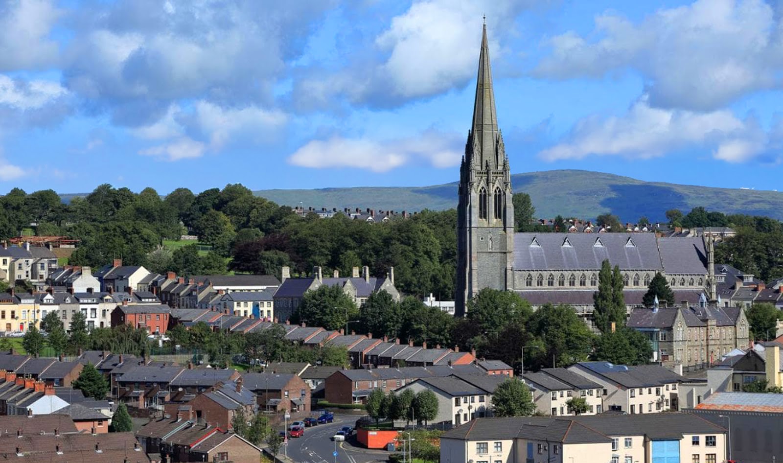
DESKTOP 2231 - DERRY, IRELAND

Derry (officially Londonderry), is the second-largest city in Northern Ireland and the fourth-largest city on the island of Ireland. The name Derry is an anglicisation of the Old Irish name Daire (modern Irish: Doire) meaning “oak grove”. In 1613, the city was granted a Royal Charter by King James I and gained the “London” prefix to reflect the funding of its construction by the London guilds. While the city is more usually known colloquially as Derry, Londonderry is also commonly used and remains the legal name.

The old walled city lies on the west bank of the River Foyle, which is spanned by two road bridges and one footbridge. The city now covers both banks (Cityside on the west and Waterside on the east). The population of the city was 83,652 at the 2001 Census, while the Derry Urban Area had a population of 90,736.The district administered by Derry City and Strabane District Council contains both Londonderry Port and City of Derry Airport.

Derry is close to the border with County Donegal, with which it has had a close link for many centuries. The person traditionally seen as the founder of the original Derry is Saint Colmcille, a holy man from Tír Chonaill, the old name for almost all of modern County Donegal, of which the west bank of the Foyle was a part before 1610. In 2013, Derry was the inaugural UK City of Culture, having been awarded the title in 2010.

This post is part of the Our World Tuesday meme,
and also part of the Travel Tuesday meme,
and also part of the Wordless Wednesday meme.

Tuesday, 3 September 2019

DESKTOP 2224 - HAARLEM, HOLLAND

Haarlem (predecessor of Harlem in the English language) is a city and municipality in the Netherlands. It is the capital of the province of North Holland and is situated at the northern edge of the Randstad, one of the most populated metropolitan areas in Europe. Haarlem had a population of 155,758 in 2014. It is a 15-minute train ride from Amsterdam, and many residents commute to the country’s capital for work.

Haarlem was granted city status or stadsrechten in 1245, although the first city walls were not built until 1270. The modern city encompasses the former municipality of Schoten as well as parts that previously belonged to Bloemendaal and Heemstede. Apart from the city, the municipality of Haarlem also includes the western part of the village of Spaarndam. Newer sections of Spaarndam lie within the neighbouring municipality of Haarlemmerliede en Spaarnwoude.

There are several museums in Haarlem. The Teylers Museum lies on the Spaarne River and is the oldest museum of the Netherlands. Its main subjects are art, science and natural history, and it owns a number of works by Michelangelo and Rembrandt. Another museum is the Frans Hals Museum of fine arts, with its main location housing Dutch master paintings, and its exhibition halls on the Grote Markt housing a gallery for modern art called De Hallen. Also on the Grote Markt, in the cellar of the Vleeshal is the Archeologisch Museum Haarlem, while across the square on Saturdays, the Hoofdwacht building is open with exhibitions on Haarlem history. Other museums are Het Dolhuys (a museum of psychiatry), the Ten Boom Museum (a hiding place for Jews in World War II) and the Historisch Museum Haarlem, across from the Frans Hals Museum.

Every year in April the bloemencorso (flower parade) takes place. Floats decorated with flowers drive from Noordwijk to Haarlem, where they are exhibited for one day. In the same month there is also a funfair organised on the Grote Markt and the Zaanenlaan in Haarlem-Noord. Other festivals are held on the Grote Markt as well, in particular the annual Haarlem Jazz & More (formerly known as Haarlem Jazzstad), a music festival, and Haarlem Culinair, a culinary event, as well as the biannual Haarlemse Stripdagen (Haarlem comic days). Bevrijdingspop is a music festival to celebrate the Dutch liberation from the Nazis after World War II. It is held every year on 5 May, the day that the Netherlands were liberated in 1945, at the Haarlemmerhout. At the same location, the Haarlemmerhoutfestival is also held every year, which is a music and theatre festival.

This post is part of the Our World Tuesday meme,
and also part of the Ruby Tuesday meme,
and also part of the Travel Tuesday meme,
and also part of the Wordless Wednesday meme.

Friday, 26 April 2019

DESKTOP 2094 - CRYSTAL BALL

View from my window through a crystal ball. Note the photo is rotated 180˚ as the image through the glass is normally seen upside down.

This post is part of the Skywatch Friday meme,
and also part of the Friday Photo Journal meme.

Wednesday, 29 August 2018

DESKTOP 1855 - HOBART, AUSTRALIA

Hobart is the state capital and most populous city of the Australian island state of Tasmania. Founded in 1804 as a penal colony, Hobart is Australia's second oldest capital city after Sydney. In 2009, the city had a greater area population of approximately 212,019. A resident of Hobart is known as a "Hobartian". The city is located in the state's south-east on the estuary of the Derwent River. The skyline is dominated by Mount Wellington at 1,271 metres (4,170 ft) high.

The city is the financial and administrative heart of Tasmania, also serving as the home port for both Australian and French Antarctic operations. Hobart was named Australia's 6th most sustainable city, by the Australian Conservation Foundation in 2010. For economic and social innovation, Hobart was the 11th placed in Australia in 2009, and listed as an innovation influencer city in the Innovation Cities Global Index scoring equal with Reykjavik, Katowice and Casablanca by 2thinknow.

This post is part of the Wordless Wednesday meme,
and also part of the ABC Wednesday meme.

Tuesday, 28 August 2018

DESKTOP 1854 - IOANNINA GREECE

Ioannina (Greek: Ιωάννινα), often called Yannena (Γιάννενα) within Greece, is the capital and largest city of the Ioannina regional unit and of Epirus, an administrative region in north-western Greece. Its population is 112,486, according to 2011 census. It lies at an elevation of approximately 500 metres (1,640 feet) above sea level, on the western shore of lake Pamvotis (Παμβώτις). Ioannina is located 410 km (255 mi) northwest of Athens, 260 kilometres (162 miles) southwest of Thessaloniki and 80 km (50 miles) east of the port of Igoumenitsa in the Ionian Sea.

Ioannina Island (Greek: Νήσος Ιωαννίνων), shown here, is an island in Lake of Pamvotis. Its area is 0,2 km2, with biggest length 800 meters and biggest width 500 meters. Until the 2011 reform of local government, it was a community within the Ioannina regional unit. Its population in 2001 was 347 and in 2011 was 219. It is reached by boat from the city of Ioannina or by ferry from the nearby shore.

This post is part of the Blue Monday meme,
and also part of the Our World Tuesday meme,
and also part of the Travel Tuesday meme,
and also part of the Wordless Wednesday meme.


Tuesday, 21 August 2018

DEKTOP 1847 - PERTH

Perth City in Western Australia is situated between the Darling Ranges and the Indian Ocean, and along the banks of the Swan River, 12 km from the ocean. The river is named after the famous black swans which can be found along the river. The city is bound by the river to the east and south. To the west of the city is Kings Park, which has over 400 hectares of natural Australian bush overlooking the city center and the Swan River.

The Swan River weaves its way through the metropolitan area to the Port of Fremantle, which has many beautiful houses, restaurants, and recreational areas along its banks. The river provides an ideal opportunity for the locals to enjoy the beautiful weather and participate in many different water sports such as boating, sailing, water skiing, wind surfing, rowing, fishing, parasailing, swimming, jet skiing, or just cruising the river on one of the many ferries.

This post is part of the Our World Tuesday meme,
and also part of the Travel Tuesday meme,
and also part of the Wordless Wednesday meme,
and also part of the Blue Monday meme.

Tuesday, 1 May 2018

DESKTOP 1735 - SALAMIS IS. GREECE

Salamis (Greek: Σαλαμίνα Salamína, Ancient and Katharevousa: Σαλαμίς Salamís), is the largest Greek island in the Saronic Gulf, about 2 km off-coast from Piraeus and about 16 kilometres west of Athens. The chief city, Salamina, lies in the west-facing core of the crescent on Salamis Bay, which opens into the Saronic Gulf. The island's main port, Paloukia, in size second only to Piraeus, is on the eastern side.

Salamis island is known for the Battle of Salamis, the decisive naval victory of the allied Greek fleet, led by Themistocles, over the Persian Empire in 480 BC. It is said to be the birthplace of Ajax and Euripides, the latter's birth being popularly placed on the day of the battle. In modern times, it is home to Salamis Naval Base, headquarters for the Hellenic Navy.

Salamis has an area of 93 square km; its highest point is Mavrovouni at 404 metres. A significant part of Salamis Island is rocky and mountainous. On the southern part of the island a pine forest is located, which is unusual for western Attica. Unfortunately, this forest is often a target for fires. While the inland inhabitants are mainly employed in the agricultural sector, the majority of Salamis' inhabitants work in maritime occupations (fishing, ferries, and the island's shipyards) or commute to work in Athens. The maritime industry is focused on the north-east coast of the island at the port of Paloukia (Παλούκια), where ferries to mainland Greece are based, and in the dockyards of Ampelakia and the north side of the Kynosoura (Greek: Κυνοσούρα = "dog tail") peninsula.

Salamis Island is very popular for holiday and weekend visits from the Athens and Piraeus area; its population rises to 300,000 in peak season of which c. 31,000 are permanent inhabitants. This supports a strong service industry sector, with many cafes, bars, ouzeris, tavernas and consumer goods shops throughout the island. On the south of the island, away from the port, there are a number of less developed areas with good swimming beaches including those of Aianteio, Maroudi, Perani, Peristeria, Kolones, Saterli, Selenia and Kanakia.

This post is part of the Our World Tuesday meme,
and also part of the Ruby Tuesday meme,
and also part of the Travel Tuesday meme,
and also part of the Wordless Wednesday meme.